- Home
- About
- Admissions
- Research
- Annual Research Report
- PNGUoT Journals
- Research Centres
- Appropriate Technology and Community Development Institute (ATCDI)
- Architectural Heritage Centre (AHC)
- Centre of Excellence for Environmental Research (CoEER)
- Melanesian Land Studies Centre (MLSC)
- South Pacific Institute of Sustainable Agriculture and Rural Development (SPISARD)
- Sustainable Energy Research Institute (SERI)
- Unitech Biotechnology Centre (UBC)
- Faculties
- Service Departments
- Bookshop
- Clinic
- Department of Open & Distance Learning (DODL)
- Human Resource
- Information & Communication Technology Services
- Matheson Library
- Public Relations Office
- PNGUoT Press
- Security
- Student Support & Facilities Centre
- Teaching & Learning Methods Unit
- Unitech Enterprise Limited
- Confucius Institute
- Online Payments
GeoPNG Congress 2025
The Inaugural Papua New Guinea National Geospatial Congress
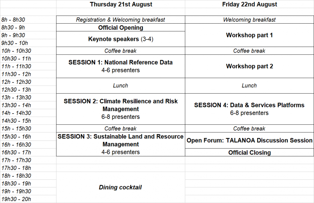
21st – 22nd of August 2025, Venue: RKLT Foyer, Papua New Guinea University of Technology, Lae 411 Morobe Province, PNG
Theme: Advancing Geospatial Technology for Sustainable and Resilient Living
COUNT DOWN TO EVENT
- 00Days
- 00Hours
- 00Minutes
- 00Seconds
Sustainable and inclusive development through Geospatial
Geospatial technology encompasses all geographic information, datasets, software solutions, and the underlying infrastructure required for data storage, validation, and dissemination in a “FAIR” manner (Findable, Accessible, Interoperable, and Reusable). Key components of geospatial technology include remote sensing technologies (such as satellite, Aerial and UAV imagery), Geographic Information Systems (GIS), Global Navigation Satellite Systems (GNSS/GPS), spatial data analytics, web mapping platforms, and large geospatial databases, etc…play a critical role in enabling the effective use of geospatial data. As a transversal digital domain, geospatial technology facilitates the characterization and monitoring of various sectors such as climate change, natural disasters, environmental protection, infrastructure planning and management, ecosystems and biodiversity, land management, water security, agriculture, energy, etc… It is integral to achieving the United Nations’ Sustainable Development Goals (SDGs). Ultimately, geospatial technology transforms raw location-based data into actionable insights, essential for addressing real-world challenges and supporting sustainable, resilient development.
Geospatial addresses a huge range of competences through a complete value chain that has to be considered exhaustively, from data producers to value-added services consumers, though infrastructures management. This with a fundamental need that the whole Geospatial ecosystem is included:
- Government Institutions – Shaping and implementing public policies that promote sustainable development and national resilience. Institutions are responsible for leveraging geospatial data to guide infrastructure planning, environmental protection, and disaster mitigation efforts.
- Education & Research – Advancing knowledge through research and innovation while fostering the next generation of geospatial professionals. Universities and research centers play a crucial role in connecting theoretical advancements with real-world applications.
- Private Sector – Driving industrial innovation, delivering cutting-edge geospatial solutions, and supporting economic development. The private sector contributes to the three pillars of sustainable development: economic growth, social inclusion, and environmental protection.
- Civil Society – Bridging the gap between technology and communities. This includes collaborating with environmental organizations, local populations, and advocacy groups to raise awareness, share knowledge, and encourage community-led participatory science initiatives.
For a successful geospatial ecosystem, inclusivity and collaboration across all key stakeholders are vital. GeoPNG congress emphasizes the importance of involving the entire ecosystem, ensuring every participant plays a role in driving sustainable and inclusive development.
A national event for community structuring and development
While our Nations have no other choice but ensure a collaborative working environment within its own ecosystem, the first step remains to ensure that each part of this ecosystem knows each other. This is the basis of any possible common project to be set up. In this way, a first aim of such a national event is to ensure the structuring of a national geospatial community, gathering all stakeholders acting in the geospatial field, leaving no one behind. This will be done through professional plenary presentations as well as more informal sessions (ex. coffee breaks, cocktail) where participants can share knowledge and experience and learn to know better each other.
Then, another key aim is to act as an incubator of collaborative inclusive projects. Or how to gather every part of the ecosystem around the table and to consider all their complementary visions on priority themes to be addressed and on what should be done to go further in addressing it. This will be done through both collective intelligence workshops and a plenary “Talanoa” discussion.
Sub-Themes to be addressed:
1. National Reference Data
This theme will showcase existing and authoritative datasets that serve as national reference information for Papua New Guinea. It aims to promote the use of standardized, reliable, and accessible data across various sectors. Examples of such datasets include national mangrove maps, Forestry data, geological data, topographic information, weather, PNGRIS and more.
2. Climate Resilience and Risk Management
Addressing critical sub-themes such as natural disasters, coastal erosion, weather forecasting, adaptive strategies, disaster risk reduction, and building future resilience to climate-related risks.
3. Sustainable Land and Resource Management
Focusing on environmental monitoring initiatives that are essential for the preservation and conservation of natural resources and biodiversity, supporting sustainable land management practices.
4. Data & Services Platforms
Emphasizing the role of data platforms in providing accessible, relevant information to local and regional stakeholders. This theme will explore the development and use of platforms that facilitate data sharing and decision-making.
5. Workshop and Special Session
In addition to the four key sub-themes, we propose a two-part workshop session designed to deepen understanding and capacity within the geospatial ecosystem. These sessions will focus on:
- Geospatial Data Collection Tools and Instruments:
Introducing participants to various geospatial data collection sources and equipment, including GNSS RTK, UAVs/drones, and field survey tools. The session will also explore key online satellite data platforms and their applications.
- Hands-On Experience and Software and tools Introduction:
Participants will gain practical experience in handling and operating geospatial software and instruments, and be introduced to essential software tools used for data processing, visualization, and analysis.
This workshop aims to provide foundational and practical knowledge to support the four proposed sub-themes. It will emphasize modern systems and tools essential for effective geospatial data capture, processing, and application, ensuring relevance to both national and regional needs.
Agenda
Keynote/Invited Guest Speakers:
Professor Ora Renagi
Vice Chancellor
Papua New Guinea University of TechnologyMr. Clement Brousse
Counsellor for Global Affairs
Embassy of France to Papua New GuineaMs. Dorothy Damar Pion
Senior Cartographer
Mineral Resources Authority of Papua New Guinea
Support to Participants
Participants will be responsible for covering their own travel costs to Lae, including airfare and accommodation expenses. However, the organizers aim to ensure that participation in the event itself is free of charge, with no registration fees required. All event-related catering and refreshments will be fully covered by the organizers, co-organizers, and potential sponsors.
Additionally, PNGUoT will provide most local land transportation within Lae, including transfers between the university campus, event venues, and Lae-Nadzab Airport. Event materials such as programs, conference kits, will also be provided at no cost to participants. Efforts will be made to secure sponsorship or partnerships to further support participants.
Sponsors/Partners